Arader Galleries
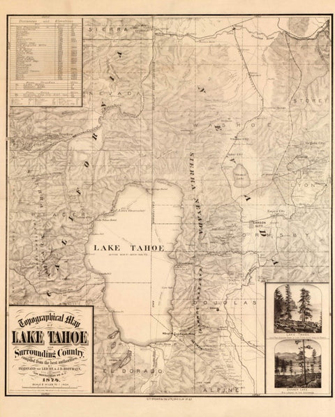
Topographical map of Lake Tahoe and surrounding country. 1874.
$ 200.00
Pickup currently unavailable
Perfect Recreation of:
Leicht, Ferdinand von.
Topographical map of Lake Tahoe and surrounding country
San Francisco, 1874
Paper Size: 24 ⅖ ” x 20 ½”
Unframed: $200
Framed: $475
Topographical Map of Lake Tahoe and surrounding country.
This topographical map showing Lake Tahoe and vicinity was published in 1874 using compiled information provided by Ferdinand von Leicht and J.D. Hoffmann. It displays cities, towns, deserted towns, mountains, lakes, rivers, mountain passes, and railroads.
During the 1870's the Virginia Mountain Range of Nevada was of great interest as news of the Comstock Lode spread far and wide. The silver-ore discovery created a tremendous amount of mining activity throughout the region. This necessitated the building of a railroad which could transport ore and serve the communities of Virginia City, Carson City, Silver City, and Gold Hill.
The Truckee River Valley was an important agricultural region and Reno was a marketing center for westbound settlers and local miners. Reno was named the new county seat of Washoe County in 1871. During that time the Virginia & Truckee Railroad Company operated a standard-gauge line south from Reno which connected the mining communities.
From the time silver-ore was discovered in the late 1850's populations in Nevada cities had boomed due to the arrival of miners, speculators, railroad men and merchants, all eager to gain from the valuable ore. The silver mines began to diminish about the time of this map’s publishing. A great fire in 1875 destroyed much of Virginia City.
The Central Pacific Railroad noted on this map was the nation’s transcontinental eastward line from San Francisco.
The Union Pacific Railroad was constructed west from Council Bluffs, Iowa. The two railroads met up at Promontory Summit in Utah in 1869 to much publicized fanfare.
Map includes distance chart, and illustrations of Donner Lake and the eastern shore of Lake.
PERFECT RECREATIONS:
Our Perfect Recreations are Archival Pigment Prints that are printed on Innova Etching Fine Art Cotton Rag Paper using Archival Watercolor Pigment Inks.
Viewed side by side - with the naked eye or under magnification - our Perfect Recreations™ are indistinguishable from the originals. The closer you get, the better they look. They completely and convincingly re-create the experience of seeing the originals.
Each Perfect Recreation™ has it all: every incredibly fine line detail of every Antique Map; every delicate watercolor brushstroke of every Audubon and every Botanical; even the subtle signs of char-acter and patina the paper shows after as much as 500 years.
Our prints are not posters; they are not reproductions -- they are Perfect Recreations as jaw-drop-ping beautiful as the originals. They are identical to the originals, and your response to them will be identical to your appreciation for the great original artworks.
We have pioneered proprietary techniques and technologies to capture and print at the highest resolution ever achieved -- our works typically provide more than ten times the detail of any previous fine art reproduction. We perfectly recreate color and texture nuances - even the sense of luminosity. We mix and apply archival watercolor pigments to the highest quality archival papers to deliver legacy-quality Perfect Recreations™.
Bespoke framing available - please reach out to us to discuss framing options.